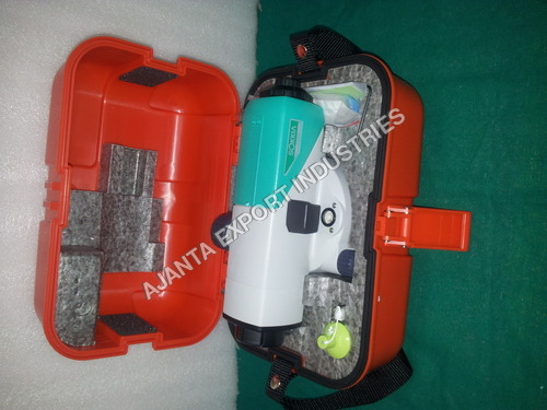
Product Description
BRAND NEW ORIGINAL SOKKIA B40 AUTO AUTOMATIC LEVEL with stand FOR SURVEYING
| Product Model | SOKKIA B40 |
| TELESCOPE |
| Length | 215mm |
| Objective aperture | 32mm(1.26in.) |
| Magnification | 24X |
| Resolving power | 4 |
| Image | Erect |
| Resolving Power | 4.0 |
| Field of View | 125(2.5m/8.2ft.) |
| Minimum focusing distance | 0.2m(7.9in.) from end of telescope
0.3m(1ft) from instrument center |
| Image | Erect |
| Reticle pattern | Cross line |
| Stadia constant | 0 |
| Stadia radio | 100 |
| Focusing knob | 1-speed |
| Sight aid | Gun sight |
| | |
| Accuracy (standard deviation for 1 km double run leveling) |
| Without micrometer | 2.0mm(0.8in.) |
| With micrometer | - |
| |
| Compensator |
| Type | Pendulum compensator with magnetic damping system |
| Setting accuracy | 0.5 |
| Working range | 15 |
| |
| Circular level |
| Sensitivity | 10/2mm |
| Mirror | Plane mirror |
| |
| Horizontal Circle |
| Diameter | 103mm(4.1in.) |
| Graduations | 1(1gon) |
| |
| General |
| Horizontal motion drive | Clampless, endless, double-sided knobs. |
| Water resistance | IPX6 (IEC 60529:2001) |
| Operation temperature | -20 to +50C(-4 to +122F) |
| Size | Width | 130mm(5.12in.) |
| Length | 215mm(8.46in.) |
| Height | 135mm(5.31in.) |
| Weight | 1.7Kg(3.7lb.) |
Unmatched Accuracy for SurveyingThe SOKKIA B40 Automatic Level provides exceptional accuracy with 2.0 mm per 1 km double-run levelling, ensuring trustworthy results for construction and land surveying projects. The finely tuned compensator and quality optics help maintain precision across diverse job sites.
Engineered for Durability and ReliabilityBuilt to endure harsh climates, the B40 boasts IPX6 dust and water protection and operates smoothly from -20C to +50C. Its robust build makes it suitable for frequent outdoor use, while the included tripod enhances stability for exact measurements.
Effortless Operation and Versatile PerformanceWith its 2-speed focusing knob, 215 mm telescope length, and 1 20 field of view, the B40 enables swift adjustments and wide visibility. The erect image and stadia readings facilitate diverse surveying tasks, making it a reliable choice for engineers and contractors.
FAQ's of BRAND NEW ORIGINAL SOKKIA B40 AUTO AUTOMATIC LEVEL with stand FOR SURVEYING:
Q: How do I set up the SOKKIA B40 Automatic Level for surveying tasks?
A: To set up the SOKKIA B40, attach the instrument securely to the included tripod stand, then use the 2-speed focusing knob to adjust clarity. Align the level using the circular bubble and begin measurements once stable orientation and focus are achieved.
Q: What benefits does the SOKKIA B40 offer to professional surveyors?
A: The B40 Automatic Level provides accurate and reliable measurements (2.0 mm per 1 km), robust protection against environmental elements (IPX6), rapid set-up, and user-friendly focusing and adjustment features, optimizing field productivity for professionals.
Q: When is it recommended to use the SOKKIA B40 in field operations?
A: This instrument is ideal for use in diverse field conditions, given its operating temperature range of -20C to +50C. It is especially suited for construction sites, land development, roadwork, and infrastructure surveys requiring high-precision leveling.
Q: Where should the SOKKIA B40 Automatic Level be stored to maintain its quality?
A: Store the B40 Auto Level in a clean, dry environment, ideally within its carrying case to protect it from dust, moisture, and mechanical knocks, thereby ensuring longevity and sustained accuracy.
Q: What is the process for achieving precise measurements with the SOKKIA B40?
A: Begin by setting up the level on the tripod and adjusting the compensator. Use the focusing knob to sharpen the target image. Read the horizontal circle (graduated to 1) and stadia readings for calculations. Always verify the bubble level before proceeding.
Q: How does the SOKKIA B40's compensator improve leveling accuracy?
A: The integrated compensator, with a range of 15 and setting accuracy of 0.5, automatically corrects small deviations caused by uneven tripod placement, ensuring consistently precise level readings for professional surveying needs.


 English
 Spanish
 French
 German
 Italian
 Chinese (Simplified)
 Japanese
 Korean
 Arabic
 Portuguese